How many California wild horses and burros will be left after the fire?

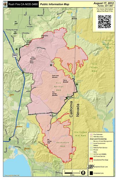
California wild horse country ~ Rush Fire map (Twin Peaks HMA) updated August 25, 2012


How many wild horses and burros were trapped by fencing in the fire?

Fire approaching Deep Cut area by Robin Blair 8.15.12


Rush Fire update in the Twin Peaks HMA

Susanville, Calif., Aug. 26, 7 a.m.–On Saturday, firefighters successfully held fire lines in the northeast part of the Rush fire in spite of gusting winds. Large dust devils were common and firefighters remained very busy fighting fire.

The threat from dust devils has led firefighters to go to the unusual length of mopping up for 500 to 1000 feet from fire lines into the burned area.  This tough work involves finding each and every hot spot and cooling them off.

In spite of the winds on Saturday, firefighters were able to hold the existing fire perimeter for the fourth day in a row.

The northeast flank is where the fire is most active.  This part of the Rush fire is in Nevada, about 25 miles northeast and east of Ravendale, Calif., near SOB, Garden and Burnt lakes, the Buffalo Hills, Antelope Basin, and Cottonwood Creek.

Helicopters with buckets dropped water on hot spots in the Cottonwood Creek area on Saturday.  In the southern and southwestern flanks of the fire on Saturday, firefighters continued repairing damage from fire-fighting activities.

The National Weather Service issued a red-flag warning for Sunday from noon to 10 p.m. because of low humidity and gusting winds.  The winds have the potential of fanning any remaining embers and hot spots.  Winds can also form dust devils that could carry hot material over containment lines into extremely dry unburned vegetation.

On Sunday, firefighters will continue their efforts to hold the fire to its current perimeter, to mop up and to make repairs on the western side of the fire.

Area and Road Closures in Effect: Public lands bounded by Highway 395 on the west, the Sand Pass road and Nevada 447 on the east, the Wendel Road on the south, and Juniper Ridge road to Buckhorn road on the north are closed. The Buffalo Meadows road in Washoe Co., Nev., is also closed.  The Ramhorn Springs and Dodge Reservoir campgrounds remain closed.

Remarks:   NOTE:  Use of chainsaws on public lands managed by BLM in northeast California and far northwestern Nevada is suspended because of extreme fire danger.  Fire officials remind residents and visitors that fire restrictions are in effect for public lands and national forests in northeast California and far northwest Nevada.  Campfires are permitted only in posted recreation sites.

For additional fire information, please go to InciWeb @ http://inciweb.org/incident/3151/


Started:  8/12/12 at 6:42 pm Expected Containment: 8/28/2012
Cause:  Lightning Committed Resources: 755 people
Fuels:  Fire is burning sagebrush, juniper,and grass Structures Threatened: 39 (20 residences; 1 commercial; 18 outbuildings)
Estimated Size: est. 320,793 acres (275,650 acres in California and 45,143 acres in Nevada) Structures Damaged or Destroyed: 1 (barn)
Containment: 66% Injuries: 3 minor


Twin Peaks HMA wildfire ~ 300K acres burned already

Twin Peaks HMA Rush Fire (Photo © Phil Perkins)

Rush Fire Update

Tuesday, August 21, 2012   8 pm

   Northern Rockies Incident Management Team – Doug Turman, IC

Fire Information Office:

530-710-8568

Staffed: 8:00 am to 6:00 pm

Started:  August 12, 2012 at 6:42 pm

Cause:  Lightning

Fuels:  Fire is burning in sagebrush, juniper, and grass

Estimated Size: 313,911 acres

Containment: 50%

Expected Containment: 8/28/2012

Committed Resources: Approximately 832 people

Structures Threatened: 9 (6 residences; 1 commercial; 2 outbuildings)

Structures Damaged or Destroyed: 1 (barn)

Injuries: 2 (both in fire camp)

Updated Rush Fire Map in Twin Peaks HMA

Location: The fire is located on Bureau of Land Management (BLM), Northern California District (BLM-CA-NOD,) Eagle Lake Field Office, approximately 15 miles southeast of Ravendale, California.  The fire is burning near a major natural gas line and transfer station, and power transmission lines that supply the Reno area and adjacent to Highway 395.

Summary:   Today firefighters made excellent progress in continuing line building and mop-up around the perimeter of the Rush Fire.  Fortunately the predicted critical fire weather conditions occurred for only a short time and fire spread was minimal.  Most of the growth occurred in the northeast part of the fire where firefighters made progress, but have not completely encircled the fire in the SOB/Burnt Lake areas. Crews will continue line building in that area tonight and tomorrow.  Tomorrow, aircraft (small air tankers and helicopters) will be used to help firefighters in this effort.  The remainder of the fireline will be patrolled and any heat found next to the fireline will be put out.  Suppression repair (mainly smoothing and water barring dozer lines) will begin on some cool portions of the fireline.

Area and Road Closures in Effect: On August 17, the BLM issued a closure order for public lands in the fire area to protect public health and safety.  The closed area is bounded by Highway 395 on the west, the Sand Pass Road on the east, and the Wendel Road on the south.  The new northern boundary for the public land closure is the Juniper Ridge, Tuledad, Stage Road, Marr Road, and Buckhorn Road extending to Nevada Highway 447 in Washoe County. Routes closed within this closure area include the Ramhorn Springs, Rye Patch Road, Buckhorn, Shinn Ranch, Stoney, Deep Cut, Smoke Creek, Skedaddle Ranch, Dry Valley, and Brubeck roads. The Ramhorn Springs Campground and the Dodge Reservoir Campground also is closed.  Today, August 21st Washoe County closed the Buffalo Meadows Road to public use.  This will allow firefighters better access and help protect firefighter and public safety.

Travelers along the Highway 395 corridor, please use caution where fire crews and equipment are working in the fire area.

Remarks:   NOTE:  Use of chainsaws on public lands managed by BLM in NE California and far northwest Nevada is suspended effective Monday, Aug. 20, due to extreme fire danger.  Fire officials remind residents and visitors that fire restrictions are in effect for public lands and national forests in northeast California and far northwest Nevada.  Campfires are permitted only in posted recreation sites.

For additional fire information, please go to InciWeb @ http://inciweb.org/incident/3151/

###