2 special needs wild horses escape death at roundup

Day 2 of Devil's Garden Roundup courtesy Devils Garden Wild Horses FB Page

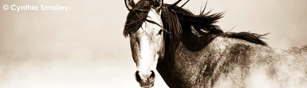
Day 2 of Devil’s Garden Roundup courtesy Devils Garden Wild Horses FB Page

Protect Mustangs will help find homes for 2 wild horses who would have been killed at Modoc Forest roundup

ALTURAS, Ca.(September 27, 2016)–Last week Anne Novak, founder and director of Protect Mustangs reached out to U.S. Forest Service staff with an offer to help find homes for any wild horses rounded up with pre-existing conditions–who would be killed–not offered a chance at adoption. Tonight Novak received the first call from Forest Service staff.

“It’s always bothered me that after wild horses heal from injuries and survive in the wild, they are chased by helicopters, rounded up and killed upon capture because they don’t seem like they would get adopted,” says Novak. “Some people don’t want a riding horse. Some people want to save a life.”

So far, two wild horses from the roundup have pre-existing conditions. One is believed to be pigeon toed due to a broken foot that healed in the wild. The other mustang’s condition is unknown at this time.

“They need to go to loving homes to become pets–not riding partners–or go to sanctuaries,” explains Novak. “They have survived in the wild and that’s a harsh life. They deserve our compassion after the roundup and they deserve to live.”

After the mustang protectors make an assessment of the wild horses with pre-existing conditions, a sanctuary might be a more suitable forever home. It’s too early to tell.

These two California wild horses from Modoc County will join their herd-mates at the Bureau of Land Management’s Litchfield holding Corrals near Susanville. There they will be prepared for adoption with the others.

Adoption applications are here: Protect-Mustangs-BLM-facility-adoption-app

    • Cost to adopt is $125.
    • Adoptions by appointment only, call (530) 254-6575.
    • Open Monday through Friday, 7 a.m. to 4 p.m. Summer hours are 6 a.m. to 3 p.m. The facilities are closed on federal holidays. Please call for current information.
    • Information is available 24 hours a day by calling 1-800-545-4256.
    • Completed adoption applications can be sent to Videll Retterath by e-mail vrettera@blm.gov or fax (530)252-6762.
    • The Corrals are located 21 miles east of Susanville , CA on US Highway 395.
    • Adopters receive title to wild horses after one year

Protect Mustangs will post photos as soon as we get them. Tax-deductible Gas donations are always needed to help us help the wild ones.

pm-ufs-devils-garden

Photo by the US Forest Service

Members of the public with questions about the BLM’s requirements for adoption, questions about the wild horses with pre-existing conditions, who want to help network homes for wild horses who would be killed for pre-existing conditions, need trainer referrals, or want some tips on how to build an inexpensive shelter are invited to email the mustang protectors at Contact@ProtectMustangs.org

“I pray we can change the trend of killing special needs wild horses at roundups,” says Novak. ‘Someone’s going to fall in love with them. After all they’re still American mustangs.”

Protect Mustangs is a 501c3 nonprofit organization dedicated to the protection and preservation of native and wild horses. www.ProtectMustangs.org


Flyover reveals low wild horse and burro population in California

Craig Downer and Jesica Johnston’s Twin Peaks Flight Report

An independent aerial survey was completed over northeastern California and northwestern Nevada for the Twin Peaks Wild Horse and Burro Herd Management Area on December 22, 2014. The objective was to estimate the population of wild horses (Equus caballus) and burros (Equus asinus) and to monitor the habitat recovery from the Rush Fire, which burned 315,577 acres in August 2012. The flight and pilot were arranged and made possible through LightHawk.

During the aerial survey a total of 62 horses and 11 burros were counted along the 174 miles of transect strips flown within the Twin Peaks Herd Management Area boundary. In addition, several groups of approximately 90 trespass cattle grazing on public land were documented in the no grazing restricted area from the 2012 Rush Fire. These were found in the south-western section of the Twin Peaks Grazing Allotment #00701 in the Skedaddle mountain range.

Using the aerial strip transect method, the survey estimated the populations of wild horses and burros in the Twin Peaks Wild Horse and Burro Herd Management Area as follows:
(a) 447-593 wild horses (including some mules)
(b) 101-120 wild burros

Follow this link to read the full report: Twin Peaks Flight Report

California wild horse range survey ~ after the Twin Peaks fire

Twin Peaks Post Fire Survey

May 18th and 19th 2013

tpopening

Twin Peaks Wild Horse and Burro Herd Management Area

Summary:

Three experienced wildlife observers with binoculars: Jesica Johnston, Carrisa Johnston, and Kathy Gregg

91 miles traveled in 11 hours – we drove slowly with many stops to look for animals

1 horse and 8 burros found

Vegetation in burn area in very good condition with many wild flowers, low grasses, a lot of cheat grass and what appears to be some Russian/Siberian crested wheatgrass (non-native).

Many juniper trees burned beyond survival but many were not burned or will survive the fire damage.  Sage areas clearly show the patchwork pattern of the fire, with many areas completely unburned within the Rush Fire perimeter.

Saw some bitterbrush drill seeding along Rye Patch Road.  Very little black burned grass noticeable now compared with last fall immediately following the Rush fire (see Rush fire report http://protectmustangs.org/?p=2729 ) and now most of the burned area is covered with spring vegetative growth.

Most notable was the lack of any animal trailing that can usually be seen and would have been very obvious with the new carpet of forage – believe this is because #1 no livestock on the public land and #2 very few wild horses and burros left on the Twin Peaks Herd Management Area. Also noticeable was the lack of horse and burro tracks and manure on the HMA.

Other animals observed: one coyote, two golden eagles, vultures, crows/ravens, two rabbits, birds, ducks and geese at Horne Ranch reservoir, 2 deer, ~ 20 antelope, two curlew, small fish in the Robbers Roost pond and some burrowing ground squirrels and pika.

Unless otherwise noted, all photographs were taken by Jesica Johnston and Carrisa Johnston.

[side note: BLM Litchfield Wild horses and burros facility approx. 200-300 animals maximum] Saturday 5/18/2013

Smoke Creek Road

42 miles on HMA – 4 hours

Very few signs of any Wild horses and burros in this area (trailing/tracks/manure)

1 adult brown burro 8 miles east of Hwy 395 and 1 adult dark brown burro 15 miles east of Hwy 395

    Wild Burro- Smoke Creek Road

Wild Burro- Smoke Creek Road

Turned around at Smoke Creek Ranch owned by Bright-Holland Corporation – gate locked with no trespassing signs and 150+ cattle visible and lush green fields all fenced off.

Rye Patch Road

10 miles on HMA – 2 hours

One set of fresh horse tracks on road and few manure piles but not stud pile (mare or only one horse?)  In the past (pre-fire) numerous manure piles and eight horses seen in this area.

We saw one old wild horse stud pile at Spanish Springs trough – new looking barbed wire strewn in pathway (very dangerous for any animal – we moved it)  No recent signs of horse.

Horne Ranch Road

26 miles approximately half in twin Peaks – 2 hours at dusk

Sunday 5/19/2013

Shinn Ranch Road

13 miles– 3 hours

6 Burros (5 adults and 1 yearling) north side of road about ¼ mile east of Highway 395

Conclusion

In our two days of observation we saw very few signs of any wild horses or burros and only saw one dark horse about a mile south of Shinn Ranch Road about 4 miles in from Hwy 395 – it was far off but 99% sure it was a horse in the far canyon and the only wild horse we saw on this trip.

La chasse aux mustangs ~ Hunting mustangs (Twin Peaks 2010)


La chasse aux mustangs

Chaque année, les autorités du Nevada, aux Etats-Unis, organisent de gigantesques captures de mustangs, ces chevaux symboles du Far West. Une fois capturés, ils sont vaccinés, castrés et envoyés dans un autre Etat. Mais pour les écologistes, se cache un autre objectif : l’exploitation du sol riche en gaz naturel.


Hunting mustangs

Each year, Nevada authorities, in the United States, organize gigantic roundups of mustangs, the symbolic horses of the Wild West. Once captured, they are vaccinated, castrated and sent to another state, But for ecologists, another objective is hidden: exploitation of land rich in natural gas.


from: http://www.wat.tv/video/chasse-aux-mustangs-341xd_2flv7_.html, filmed in 2010. Anne Novak was honored to work with the director and cinematographer on this project–bringing light to the hidden lies.

How many California wild horses and burros will be left after the fire?

California wild horse country ~ Rush Fire map (Twin Peaks HMA) updated August 25, 2012


How many wild horses and burros were trapped by fencing in the fire?

Fire approaching Deep Cut area by Robin Blair 8.15.12


Rush Fire update in the Twin Peaks HMA

Susanville, Calif., Aug. 26, 7 a.m.–On Saturday, firefighters successfully held fire lines in the northeast part of the Rush fire in spite of gusting winds. Large dust devils were common and firefighters remained very busy fighting fire.

The threat from dust devils has led firefighters to go to the unusual length of mopping up for 500 to 1000 feet from fire lines into the burned area.  This tough work involves finding each and every hot spot and cooling them off.

In spite of the winds on Saturday, firefighters were able to hold the existing fire perimeter for the fourth day in a row.

The northeast flank is where the fire is most active.  This part of the Rush fire is in Nevada, about 25 miles northeast and east of Ravendale, Calif., near SOB, Garden and Burnt lakes, the Buffalo Hills, Antelope Basin, and Cottonwood Creek.

Helicopters with buckets dropped water on hot spots in the Cottonwood Creek area on Saturday.  In the southern and southwestern flanks of the fire on Saturday, firefighters continued repairing damage from fire-fighting activities.

The National Weather Service issued a red-flag warning for Sunday from noon to 10 p.m. because of low humidity and gusting winds.  The winds have the potential of fanning any remaining embers and hot spots.  Winds can also form dust devils that could carry hot material over containment lines into extremely dry unburned vegetation.

On Sunday, firefighters will continue their efforts to hold the fire to its current perimeter, to mop up and to make repairs on the western side of the fire.

Area and Road Closures in Effect: Public lands bounded by Highway 395 on the west, the Sand Pass road and Nevada 447 on the east, the Wendel Road on the south, and Juniper Ridge road to Buckhorn road on the north are closed. The Buffalo Meadows road in Washoe Co., Nev., is also closed.  The Ramhorn Springs and Dodge Reservoir campgrounds remain closed.

Remarks:   NOTE:  Use of chainsaws on public lands managed by BLM in northeast California and far northwestern Nevada is suspended because of extreme fire danger.  Fire officials remind residents and visitors that fire restrictions are in effect for public lands and national forests in northeast California and far northwest Nevada.  Campfires are permitted only in posted recreation sites.

For additional fire information, please go to InciWeb @ http://inciweb.org/incident/3151/


Started:  8/12/12 at 6:42 pm Expected Containment: 8/28/2012
Cause:  Lightning Committed Resources: 755 people
Fuels:  Fire is burning sagebrush, juniper,and grass Structures Threatened: 39 (20 residences; 1 commercial; 18 outbuildings)
Estimated Size: est. 320,793 acres (275,650 acres in California and 45,143 acres in Nevada) Structures Damaged or Destroyed: 1 (barn)
Containment: 66% Injuries: 3 minor


Help California’s last wild horses stay on the range

Fire endangers wild horse habitat

Rush Fire photo August 20, 2012 (Photo © Phil Perkins)

Close to 300,000 acres of the Twin Peak wild horse range have burned as of midnight August 20th.

We are very grateful to the Rush fire crews working to contain the fire, protect the land, livestock, wild horses and burros and especially the community.

We ask the BLM to find a way to help the wild horses on the range by bringing them food and water as needed–until the forage grows back.

Rounding up California’s last herd of wild horses and removing them from their herd management area is wrong. We don’t want them to lose their legally designated range to livestock, energy and mining use. These other forms of public land use can move elsewhere for a while, if needed, but California’s wild horses need their home on the range.

Photo © Cynthia Smalley, all rights reserved

Rush fire info and map: http://inciweb.org/incident/3151/

Twin Peaks fire update


Twin Peaks HMA Rush Fire on Rye Patch Road August 18, 2012 (Photo by BLM)


Magic’s family in the Twin Peaks HMA ~ Rush Fire location (Photo © Grandma Gregg, all rights reserved.)

Rush Fire Update

August 20, 2012   8 am

   Turman’s Northern Rockies Incident Management Team

Fire Information Office:

530-710-8568

Staffed: 8:00 am to 6:00 pm

Started:  August 12, 2012 at 6:42 pm

Cause:  Lightning

Fuels:  Fire is burning in sagebrush, juniper, and grass

Estimated Size: 270,683 acres

Containment: 50%

Expected Containment: 8/25/2012

Committed Resources: Approximately 677 people

Structures Threatened: 9 (6 residences; 1 commercial; 2 outbuildings)

Structures Damaged or Destroyed: 1 (barn)

Injuries: 2 (both in fire camp)

Location: The fire is located on Bureau of Land Management (BLM), Northern California District (BLM-CA-NOD,) Eagle Lake Field Office, approximately 15 miles southeast of Ravendale, California.  The fire is burning near a major natural gas line and transfer station, and power transmission lines that supply the Reno area and adjacent to Highway 395.

Summary:   Line construction and suppression efforts will continue along the north eastern edge of the fire along the Buckhorn Road. The fire remains active along this edge. Burning operations on the southern edge of the fire near Wendel Road were successfully completed yesterday, and crews worked late into the night.  Today, crews will concentrate suppression efforts along the north eastern flank, south of Buckhorn Road; the eastern edge east of the Rush Creek Ranch, and in the Wendel Road area.  Additionally, crews will continue mop up and fire line construction along other areas of the fire’s perimeter.  Air support will available and used as needed.

Tomorrow there is a Fire Weather Watch forecasted for afternoon winds from the SW approaching 30 to 35 mph.

Today at 0600 the Northern Rockies Incident Management Team assumed command from NorCal Team 2.  Transitions of this sort are common, and operations should remain seamless.

Area and Road Closures in Effect: On August 17, the BLM issued a closure order for public lands in the fire area to protect public health and safety.  The closed area is bounded by Highway 395 on the west, the Sand Pass Road on the east, and the Wendel Road on the south.  The new northern boundary for the public land closure is the Juniper Ridge, Tuledad, Stage Road, Marr Road, and Buckhorn Road extending to Nevada Highway 447 in Washoe County. Routes closed within this closure area include the Ramhorn Springs, Rye Patch Road, Buckhorn, Shinn Ranch, Stoney, Deep Cut, Smoke Creek, Skedaddle Ranch, Dry Valley, and Brubeck roads. The Ramhorn Springs Campground and the Dodge Reservoir Campground also is closed.

Travelers along the Highway 395 corridor, please use caution where fire crews and equipment are working in the fire area.

Remarks: Fire officials remind residents and visitors that fire restrictions are in effect for public lands and national forests in northeast California.  Campfires are permitted only in posted recreation sites.  Chainsaws may not be used after 1:00pm daily.

For additional fire information, please go to InciWeb @ http://inciweb.org/incident/3151/

###